|
| |
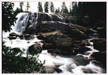
Falls on the Florida River. Click on the image to see a larger version. Photo by Donna Ikenberry.
Weminuche Wilderness Area
Government information and links are at the bottom of this page.
Located in San Juan and Rio Grande National Forests
Neighboring towns: Durango, Bayfield, Pagosa Springs, Baxterville, Southfork, Creede, Lake City, Silverton, Ouray
More than a half million acres in size, the Weminuche Wilderness is Colorado's largest, more than twice the size of Flat Tops, the second largest. As might be expected, the area contains the headwaters of dozens of major streams and rivers, feeding both the Rio Grande and San Juan rivers, two of the Southwest's most ecologically and culturally significant waterways. Weminuche's great size encompasses broad and diverse environments: cascading rivers swollen with snowmelt; immense glacial valleys; windswept ridges of the Continental Divide; and the seemingly unreachable summits of skyscraping granite, crags that cast magical reflections in alpine pools at dawn's soft light.
The Weminuche Wilderness offers spectacular examples of dramatically different mountain landscapes. The granitic Needle Mountains in the western end of the wilderness contain its three 14,000 foot peaks as well as equally inspiring summits, such as Arrow and Vesatal peaks in the nearby Grenadier Range. To The south, limestone mesas slope gently towards the high summits,. Farther east are ragged peaks and soaring cliffs, formed over millions of years as volcanic eruptions covered the landscape. Several periods of glaciation later creating the dozens of cirque lakes (63 to be precise) that dot the high country. The Animas River gorge cuts through the westernmost segment of the wilderness, beneath the distinctive metamorphic peaks of the West Needle Mountains. Thousands of tourists annually marvel at the area's beauty from the clacking cars of the Durango - Silverton Narrow Gauge Railroad, which parallels the river, climbing precipitously to the walls of the narrow canyon.
The Continental Divide Trail runs through the heart of the area for approximately 80 miles. The Colorado Trail crosses 21 miles of the Wilderness from Molas Pass to the Rio Grande, and brings the total trail miles to close to 500. Here is Colorado backpacking at its best - but most crowded. No other Wilderness in the state gets as much traffic or abuse. For the sake of this Wilderness, you might consider visiting a nearby roadless area - Carson Peak to the north or San Miguel to the northwest - where the beauty is undiminished and, as yet, unspoiled.
Size: 492,418 acres
Elevation: 8,000 to 14,000 feet
Miles of trails: 475
Year designated: 1975, 1980, 1993
Hunting areas: 74, 75, 76, 77, 78, 751
For more information contact:
San Juan National Forest,
http://www.fs.fed.us/r2/sanjuan/contact/
Rio Grande National Forest,
http://www.fs.fed.us/r2/riogrande/contact/

NOTE: coloradowilderness.com gratefully appreciates the eloquent descriptions of our wilderness areas provided by Mark Pearson, author of "The Complete Guide to Colorado's Wilderness Areas", Westcliffe Publishers, Englewood, CO. The book also contains many beautiful pictures by renowned photographer and Colorado resident John Fielder.
info@coloradowilderness.com
Site designed and maintained by IOR Productions, PO Box 540, Meeker, CO 81641
Copyright 1999 IOR Productions. All rights reserved.
If you're living
in Colorado then you know that new Colorado homes
are beautiful. People who are looking to buy
Colorado real estate know that Colorado
property is more affordable than ever which makes Colorado
a great place to live.
|