|
| |
Powderhorn Wilderness Area
Government information and links are at the bottom of this page.
Located in Gunnison National Forest
Neighboring towns: Lake City, Gunnison, Creede
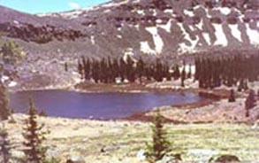
On the northern fringe of the San Juan Mountains, the Canibal and Calf Creek plateaus create a seemingly endless, undulating plain of tundra, broken only by several steep escarpments bejeweled by Powderhorn and other lakes. Local researchers at Western State College in Gunnison call these plateaus the largest continuous extent of tundra in the lower 48 states, a claim that is easy to believe as you stride across their limitless expanse. Few other areas in Colorado give rise to an equivalent sense of vastness, for the 13,000 foot plateau affords panoramic views of the San Juan, Elk and Sawatch ranges and their numerous fourteeners.
Lava and ash thousands of feet thick underlie these high plateaus. Glaciation chiseled abrupt cirques and scoured depressions now filled with water, proven attractions for generations of anglers. Though located on the northern flank of the usually wet San Juan Mountains, the lower elevations of the Gunnison Basin receive modest precipitation and, as a result, sagebrush meadows characterize the wilderness here. Widely separated ponderosa pines intermingle with the sagebrush and wetter pockets support groves of aspen. Moving higher onto the plateaus, precipitation increases markedly and fills the abundant lakes and beaver ponds of long, shallow, willow-packed valleys. Elk and mule deer find this habitat to their liking, and several hundred of both roam the area.
Cannibal Plateau was named for Colorado's famous man-eater, Alferd Packer, who supposedly dined on five friends while lost near here during the winter of 1874!
The southern one-fourth of Powderhorn is managed by Gunnison National Forest, and the northern three-fourths by the Bureau of Land Management. About 45 miles of trails access this seldom-visited area.
Size: 61,510 acres
Elevation: 8,600 to 12,600 feet
Miles of trails: 45
Year designated: 1993
Hunting areas: 66
For more information contact:
Gunnison & Uncompahgre National Forests, 2250 Highway 50, Delta, CO 81416 (970)874-6600 Forest Headquarters
This e-mail will be distributed to the correct Ranger District.
Grand Valley Ranger District, PO Box 330, 218 High Street, Collbran, CO 81624 (970)487-3534
Gunnison Ranger District, 216 N. Colorado, Gunnison, CO 81230 (970)641-0471
Ouray Ranger District, 2505 S. Townsend, Montrose, CO 81401 (970)240-5400
Paonia Ranger District, PO box 1030, North Rio Grande Ave., Paonia, CO 81428 (970)527-4131
Gunnison Ranger District, PO Box 89, Lake City, CO 81235 (970)641-0471 or (970)944-2500
Grand Valley Ranger District, 2777 Crossroads Blvd., Grand Junction, CO 81506 (970)242-8211
Norwood Ranger District, PO Box 388, 1760 Grand Ave., Norwood, CO 81423 (970)327-42261

NOTE: coloradowilderness.com gratefully appreciates the eloquent descriptions of our wilderness areas provided by Mark Pearson, author of "The Complete Guide to Colorado's Wilderness Areas", Westcliffe Publishers, Englewood, CO. The book also contains many beautiful pictures by renowned photographer and Colorado resident John Fielder.
info@coloradowilderness.com
Site designed and maintained by IOR Productions, PO Box 540, Meeker, CO 81641Copyright 1999 IOR Productions. All rights reserved.
|